
Garmin eTrex 10 Review
FEATURED PRODUCT

Garmin eTrex 10 Handheld GPS
The Garmin eTrex 10 is a rugged and durable hand-held GPS that does everything you need in order to find your way in the wilderness. Light, waterproof, accurate, and with excellent battery life, it's no wonder that it's a favorite amongst outdoor enthusiasts worldwide. It includes a global basemap, geocaching, and lots more useful features to keep you moving in the wild. View Latest DealIn this day’s age, we tend to rely on our phones for any kind of GPS mapping rather than using a hand-held GPS. But phones don’t have the features or the accuracy you get from a true GPS and in order to enjoy hiking with no signal and always be able to find you’re way, you’re going to need a proper hand-held.
There are loads of hand-helds on the market these days but if you’re looking for something that is affordable and does the basics very well, then the Garmin eTrex 10 is the place to start. It’s small and light with a great battery life plus the GPS is insanely accurate. It does everything you’d expect of a basic GPS very well but does lack those extra features of more expensive options.
In this article, we take a deep dive into all the details of the Garmin eTrex 10 and look at the design, usability, navigation, geocaching, and more. Keep reading to find out if this is the hand-held GPS for you. Spoiler alert, it probably is.
Pros
- It's very affordable for the quality
- Small and light for backpacking with
- Is great for Geocaching with
- The GPS is quick to locate you and deadly accurate
- It's an easy GPS to use and navigate with
- The battery life is excellent at 25 hours
- Takes AA batteries, so you can always add new ones without having to charge
- Comes with a Worldwide Basemap
- It's durable and waterproof to IPX-7
Cons
- There are no detailed maps included
- The screen is not in color
- The instructions are pretty sparse
- It has a small amount of memory
- There is no SD card slot for extra memory and easy transfers
Product Rating
Product Information
- Worldwide basemap
- 2.2" monochrome display, easy to read in any light
- GPS and GLONASS satellites for faster positioning
- Paperless geocaching
- 25-hour battery life with 2 AA batteries
- Waterproof to IPX7 standards for protection against splashes and rain
- See high and low elevation points
- Store waypoints along a track
- Estimate time and distance between points
- Dimensions: 2.1 x 4.0 x 1.3 inches
- Weight: 5 oz.
- Additional features including; Digital compass, Area calc, Sun & Moon,
- Hunt & Fish, Calendar, Alarm, Stopwatch, Calculator
Design & Durability
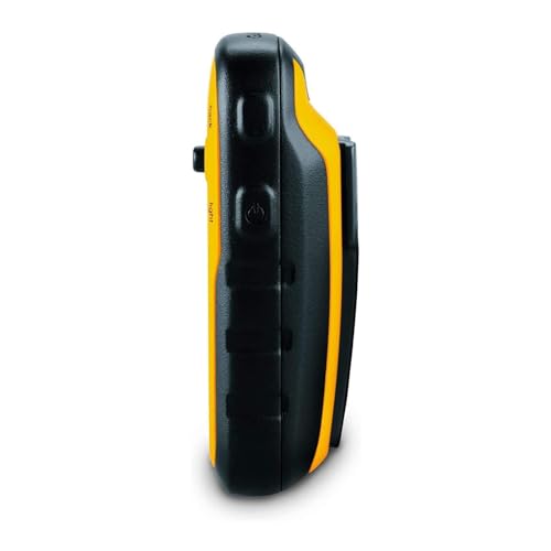
The Garmin eTrex 10 has been designed with a hiker and backpacker in mind. The dimensions are pretty small at 2.1 x 4.0 x 1.3 inches and it weighs just 5 oz with the batteries inside. You’ll easily be able to keep it handy in your pocket or in the side pockets of your backpack for quick access while moving around.
The unit is yellow and black, making it easy to see in your bag. This is really useful, as it can be hard to find when deep in your backpack due to its small size. It is surrounded by a thick plastic casing that protects it from any accidental damage and there are ergonomic grips on the side so it stays in your hands. The grips also help the GPS bounce if you do happen to drop it.
Waterproofing
The eTrex 10 is waterproof to an IPX7 rating. This doesn’t mean you can take it diving and snorkeling but it does mean it’ll survive underwater for 30 minutes up to 1 meter in depth. So if you drop it in a puddle, shallow stream, or use it in the rain, don’t worry about it, the eTrex 10 can handle it.
Display
The display featured on the e-Trex 10 is 2.2 inches and is a simple black and white (monochrome) screen. It has a 128 x 160-pixel resolution which quite low but it can be seen in all kinds of light because the display is transflective and won’t reflect the sun back at you.
Unfortunately, it doesn’t give the detail and clarity that we have come to expect with smartphones but you would have to pay a lot to get a GPS with that kind of display.
Battery Life
The eTrex 10 has great battery life. It uses two AA batteries as its power source which is really useful. They are cheap, easy to replace, you can always have a backup and they are really light.
Off one pair of AA’s, you can expect 25 hours of use, which is pretty incredible. This is thanks to the low resolution and black and white screen that doesn’t chew the battery.
Usability

When thinking about GPS usability we want to look at the interface, the controls, and how easy it is to make the GPS do what you need it to. Have a read below to see how the Garmin eTrex 10 does.
Interface
The interface is a little ‘old school’ but for an affordable hand-held GPS, this is what you should expect. Once you’re inside it is simple to navigate around but the instructions that come with it are pretty awful and it’s better to check out the online instructions that are far more detailed.
After you have turned it on, the main menu gives you 6 options; map, where to, compass, a trip computer, mark (a waypoint), and settings. There are a lot more features to be found and it’s best to check out the online instructions and have a play with them in the garden.
Control Buttons
The e-Trex 10 comes with 5 side buttons and one joystick just by the screen. The joystick is the main button that you use to scroll and click through all the menu options. It is very easy to use but may get some getting used to if you haven’t used one before. You can also use it to mark a quick waypoint at the moment by pressing and holding it.
The five buttons on the side are easy to use and give you some handy shortcuts. You can zoom in, zoom out, go straight to the menu screen, go back a step, turn it on/off, and adjust the light settings for better contrast if you need it. If you want to save battery, try and keep your light settings low.
The great thing about being a button-only GPS is that it works in all weather conditions, no matter how wet it is and with gloves on. Some touch screen GPS’ simply don’t respond when wet or with gloves and can get frustrating.
Navigation
As you might already know, the Garmin eTrex 10 comes with no mapping at all bar a world base map. This means you’ll be putting waypoints on a pretty much a blank page that makes it hard to navigate at the moment, unlike using topo maps that have all the details of your surroundings.
Your best plan with the eTrex 10 is to do your pre-planning at home using Garmin’s Basecamp software. This will allow you to layout your trip with the Track Draw feature and estimate the time and difficulty. Once you have drawn out your route, you can then transfer it to the eTrex-10 via the included USB cable.
When you want to use your saved routes, you can pick the trip from the menu page and follow your route to your destination. It’ll store up to 100 tracks, 1000 waypoints, and 50 routes on its 6MB of internal memory. It is a bit limiting and you may have to add and remove a lot. Plus there is no SD card slot for it either.
GPS and GLONASS
The eTrex 10 uses both GLONASS and GPS satellites to give you a more reliable signal and better accuracy. It’ll find you really quickly and keep a lock on your location as you travel around.
If you want to know which satellites you are using, you can dive into the ‘satellite’ option to see how many and if you’re using GPS or GLONASS. This option will also tell you the signal strength, location, accuracy, and elevation.
GPS HotFix
The eTrex 10 is exceptionally fast at finding your location when you turn it on and this is thanks to the GPS HotFix feature. It predicts your location based on previous data where you have used the GPS to find you faster. If you do use it in a faraway new location, be patient for it to find your new location.
WAAS
The eTrex 10 also uses WAAS (Wide Area Augmentation System) that only works in North America. The WAAS system uses satellites and ground stations in combination to increase GPS accuracy through signal correction. This means your location will be accurate to 3 meters 95% of the time.
Geocaching
If you’re into Geocaching then the eTrex 10 is a great hand-held GPS for you. It is excellent for paperless geocaching. Simply add the Geocache GPX files from your Geocaching account to the eTrex 10.
Once loaded, just find the GPX file and hit go. You can even set the eTrex 10 to CHIRP so that it sends out an alarm to tell you when you’re nearby the cache. The eTrex 10 is awesome for this thanks to its excellent accuracy.
Once you have found the cache, just click on Geocache on the menu and pick the log attempt. It’s very simple and easy to use and makes running around in the wild a lot of fun.
Other Features
The Garmin eTrex 10 comes with quite a few additional useful features that’ll add some value to your time in the outdoors.
Digital Compass
There is a digital compass on the eTrex 10 that you can use for navigation. It’s pretty accurate but you need to keep moving for it to calibrate effectively. You can also use the compass as your navigation tool by adjusting the settings so it always points in the direction you want to go in.
Area Calculation
The eTrex 10 can calculate the size of a particular area for you. Simply find the area calculation feature in the menu and press start. Then you just walk around the area you want to know the size of and once you’re done it’ll tell you the area.
Sun and Moon
The eTrex 10 gives you sunset, sunrise, moonset, and moonrise times. This is really handy when you want to avoid walking through the dark or want to plan a moonlight evening, sunrise or are looking for a dark night to see some bioluminescence.
Hunt and Fish
If you love to hunt and fish, you’ll love this feature. The eTrex 10 will let you know the best dates and times for fishing and hunting in your location.
Calendar and Alarm Clock
It’s not likely that you’ll need the calendar or alarm but they could come in useful if your other electronics die. It’s also handy to have a backup alarm for any early rises you might be planning.
Calculator and Stopwatch
These functions are great if you want to time anything and the calculator is useful if you’re trying to work out some figures, especially if you’re going on some kind of science project.
Value For Money
The Garmin eTrex 10 is awesome value for money are far as we are concerned. For under $100 you get a rugged, durable, waterproof GPS that will take you anywhere you need to be, as long as you do some pre-planning.
It’s not as sophisticated as other hand-held GPS’ but it’s over half the price. So for a very reasonable amount of money, you will be able to get the best of a GPS that will get you from A to B, and you can have fun Geochaing with.
Rating
The Garmin eTrex 10 scored a whopping 88 on our rating system which is a pretty great score. It did lose marks for the dated display, interface, and for lack of maps. But for the price, it does a great job of giving you an accurate location and being able to survive a rough life on the trail.
Verdict
The Garmin eTrex 10 is one of the cheapest hand-held GPS’ on the market and for the price, we think it’s pretty epic. The accuracy and rugged waterproof durability combined with the great battery life make it the best choice for anyone looking for a simple GPS.
You do lose the features of a more expensive GPS, like Topo maps and a color screen but if you don’t really need them, why pay for them?
If you’re looking for a simple GPS that does the basics well, then the Garmin eTrex 10 is a great choice.