
Best Hikes In Zermatt (Families, Beginners & Experienced)
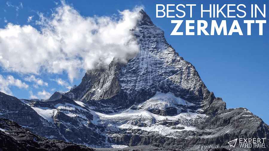
The Alps is the highest mountain range in Europe, and it has to be one of the most famed alpine areas in the entire world. Not only is the Alps home to the mighty Matterhorn, a prize-worthy pyramid-shaped peak nesting between the borders of Switzerland and Italy, but there are enough glaciers, gorges, and lakes to keep you entertained for days.
Zermatt is a small municipality that has long drawn in visitors from around the world thanks to its proximity to some of the finest scenery the Swiss Alps has to offer. Zermatt town is located at the foot of the Matterhorn, which makes a particularly impressive addition to the backdrop of many walks in the area, and the local flora is spectacular too, especially during the spring and summer months.
If you’re looking for a base from which to explore some of the Alps’ most impressive hiking trails, then Zermatt is the holiday destination for you. Here, we brought you a varied selection of the best hikes around Zermatt – with various lengths, difficulties, and landscapes, there really should be a hiking trail for everyone!

Image courtesy of WikiMedia
Tips For Hiking In Zermatt
Okay, so, just before we dive into things, there are a few things you should bear in mind when preparing for a hiking holiday in Zermatt. Firstly, Zermatt itself is actually a car-free zone, so don’t expect to hire a car a the airport and rock up on four wheels! Fortunately, it’s very well served by public transport, and there are trains running to Zermatt from all of the nearest airports (Geneva, Sion, Zurich, and even Milan over in Italy) – plus the ride itself will take you through some fabulous countryside.
Alternatively, depending on where you’re staying, your accommodation may provide airport shuttles. Once you’re in Zermatt, be prepared to hop on further trains, funiculars, and even gondolas to reach the start of your hike (or to return).
Secondly, as much as Zermatt is an awesome place to visit, it’s not so awesome on the wallet… it’s notoriously expensive, and this includes public transport as well as accommodation and dining out. You can cut costs by hiking further and avoiding some of the additional travel fares, but in some cases, they will be unavoidable – it’s not so expensive that it should put you off, just make sure you’ve saved up in advance and won’t get caught out unawares!
Thirdly, we definitely recommend visiting Zermatt in the summer months (June to September). During this time, the weather is perfect for hiking – at 12-25 degrees celsius it’s not too hot or too cold. It is possible to hike in the colder months, but some routes may be closed to make sure you do your research first.
Finally, if maps aren’t your thing and you’re after a stress-free hiking experience, don’t forget that there are tonnes of tour operators in the area that will be more than happy to guide you around the slopes.
The Gornergrat (from Riffelalp)

Hike Details
- Trail length: 6.4 km (one way); various routes available
- Elevation Change: 900 m
- Hiking Time: 2-2.5 hours (uphill, one way)
- Starting Point: Riffelalp
- Difficulty: Easy to moderate
- Transportation: Both Riffelalp and Rifelsee (and even the Gorngrat itself) are on the train line that runs from Zermatt.
We’re starting off our list of the best hikes in Zermatt with an absolute classic, the hike to Gornergrat from Riffelalp. In terms of scenery, this really is one of the most impressive walks that Zermatt has to offer.
As you set off towards Riffelsee Lake from Riffelalp, brace yourself for one of the most picturesque scenes of your life. You’ll encounter crisp mountain waters that create a mirror image of the mighty Matterhorn looming in the distance – probably one of the most iconic landscapes around Zermatt. This stretch of the hike is very easy physically, and suitable for even small children, and many families simply head back at this point after soaking up the magical scenery.
However, if you have the time and energy, we definitely recommend the next leg of the hiking trails too. As you make your way up to Gornergrat, the Matterhorn will remain a prominent feature of the snowy landscape. The trail is a little steeper here, but you’ll be rewarded with stunning views of the Gorner Glacier. The Gornergrat Hotel is perfectly situated to provide much-needed refreshments after your hike, and it offers spectacular views too.
From here, you can hop on the Gornergrat Railway back to Riffelalp. The ride will cost you $20-30 dollars, depending on the season, but it’s a magical one that winds its way through some spectacular scenery and is definitely one for the memory books. Alternatively, if you’d rather save the money, you can simply head back down the way you came.
One of the great things about this hiking trail, aside from its stunning scenery, is its flexibility – you can start directly at Riffelsee Lake if you prefer, you can double-up by walking all the way up and down again, and you can take a U-turn along the way if things get a bit much thanks to the handy rail service – so you really can make of this hike what you will.
Five Lakes Trail

Hike Details
- Trail length: 9.8 km
- Elevation Change: Ascent distance: 165 m; descent distance: 454 m
- Hiking Time: 2.5 hours
- Starting Point: Blauherd
- Difficulty: Easy
- Transportation: From Zermatt, catch a funicular up to Sunnegga. From there, you take the gondola to Blauherd.
It’s easy to conjure up images of mountains, mountains, and more mountains when you picture Zermatt, but its lakes are also out of this world. So, why not try one of the Zermatt hiking trails everyone loves.
The Five Lakes Trail is a very easy-going hike that’s suitable for families and doesn’t require a particularly high level of personal fitness. What’s more, as the name suggests, you’ll pass five of the best mountain lakes that Zermatt has to offer – Stellisee, Grindjisee, Grünsee, Moosjisee, and Leisee.
During the warmer summer months, you can take a refreshing dip in the Grünsee and Leisee lakes, so pack your swimming gear! The tranquility of the lakes is something you can’t help pick up on, and the way their calm waters reflect the nearby mountains, including the Matterhorn, is beautiful.
The route begins in Blauherd, which is accessible via an awesome gondola ride through the mountains from Sunnegga (make sure you have your camera at the ready), which is in turn reached via a funicular ride from Zermatt. Although this might seem like a faff, it’s really more of an adventure really, with astounding views every inch of the way – you can definitely get your kids excited for the gondola and funicular rides!
From Blauherd, you’ll wind your way down the valley, passing the lakes as you go, and eventually loop back to Sunnegga (so more downhill than uphill for a change, yay). We absolutely love this scenic hike as it lets you soak in some absolutely incredible sights without having to work up too much of a sweat (because it’s nice to take it easy sometimes!).
The Matterhorn Glacier Trail

Hike Details
- Trail length: 6.6 km; with an option to extend
- Elevation Change: Ascent distance: 175 m; Descent distance: 515 m
- Hiking Time: 2-2.25 hrs; with an option to extend
- Starting Point: Trockener Steg to Schwarzee
- Difficulty: Easy to moderate
- Transportation: From the Zermatt-Furi station, catch a gondula ride up to Trockener Steg. From Schwarzsee, you can catch a gondula or hike back down to Zermatt.
Not only is the Matterhorn Glacier Trail an absolute delight for outdoor enthusiasts, but it’s also a fantastic hike for anyone interested in geography. You’ll walk in the wake of retreating glaciers, and you can admire how life begins to sprout not long after the icy planes have drawn back. You might even find some historical artifacts along the way – but these must be handed into the tourist information center so that the archaeologists can examine them!
If you’re keen to learn more about the glacial retreat, then you’ll be pleased to know that that are information boards along the trail telling the story of what’s occurred, and you can always read up on it in advance too (see here for some history on the glaciers themselves).
As the name suggests, as well as glaciers you’ll also get to ogle at the Matterhorn for much of this walk, as you head across the eastern bowl of the famed Matterhorn peak. After this rocky clamber, you’ll be greeted with some refreshing greenery for the next leg of the hike.
This is a fairly high-altitude hike, with the lowest and highest points located at 2,570 m and 2,928 m, respectively, which means you’ll get fantastic views of the surrounding landscapes, which include luscious forests lying below the snowcapped peaks.
The starting point for the 6.6 km hike is Trockener Steg, which is reached by gondola from Zermatt. From there you head to Schwarzsee, via Hirli lift station, where you can catch the gondola back to Zermatt. Like many things in Switzerland, the ride is not cheap (from Zermatt to Schwarzsee can cost over $40 for an adult; see here for up-to-date ticket prices).
If you’re looking for a way to keep costs down, then it’s possible to hike all the way back down to Zermatt, but you’ll have to allow an extra 2-3 hours for your hike.
The Botanical Trail

Hike Details
- Trail length: 8 km round trip
- Elevation Change: Ascent distance: 732 m
- Hiking Time: 2.25 hrs up; 1.5 hrs down
- Starting Point: Zermatt town to the Hotel du Trift
- Difficulty: Easy to moderate
- Transportation: On foot from Zermatt.
When you’re surrounded by towering peaks and vast expanses of mountainous lakes, it can be easy to overlook some of the smaller details that are right in front of you. The Botanical Trail is a great way for you to experience the smaller delights that the alpine landscapes surrounding Zermatt have to offer.
You’ll encounter flora of an astounding array of colors, and there are handy information boards along the way so you can quickly brush up on your botany. Key things to look out for include Haller’s pasque flower (Pulsatilla halleri), a rare and beautiful flower found in the Zermatt area, as well as edelweiss, probably the most iconic symbol of the alps (if you want to see it in bloom though, you’ll have to be around from July to September time).
As always, such a botanical bouquet is irresistible to the many bugs in the area, and you’ll likely encounter many along the way – keep your eyes open for the beautiful Apollo butterfly (sadly it’s endangered and might not be around forever).
Unlike the other routes we’ve highlighted, this one actually begins in Zermatt town. It might not be a long walk, but it requires a moderate level of fitness, as you’ll be marching uphill for the entire journey – you’ll climb almost 900 m during the 4 k hike! The end-point of Trift is home to the Hotel du Trift, where you can pause and refuel before making your way back down the hill.
Hornlihutte (from Schwarzsee)

Hike Details
- Trail length: 8 km; options to extend
- Elevation Change: 967 m incline
- Hiking Time: 3 hrs
- Starting Point: Schwarzsee
- Difficulty: Moderate
- Transportation: You can reach Schwarzsee via gondula from Zermatt and vice versa (it's also possible to hike between Schwarzsee and Zermatt).
And last, but by no means least on our list is the hike from Schwarzsee up to Hornlihutte – because no trip to Zermatt is complete without a trip to the Matterhorn basecamp, right?
It’s a consistently steep 4 km hike from Schwarzsee to Hornlihutte and, although the trail is clearly marked, you’ll encounter a few scrambly patches, drop-offs, and even ladders – so it’s definitely not a hike for the fainthearted! The trail will take you way above the treeline, offering awesome views of the valley far below.
Once you reach the top, you’ll feel a real sense of achievement and the sight of climbers preparing to summit the might Matterhorn may well give you the climbing bug yourself – we certainly wouldn’t be surprised if you return a few months later, climbing gear in hand. As you sit back and relax at the foot of this world-famous peak, you really will feel like you’re in the heart of the Alps.
To return to Schwarzsee, head back down the way you came for an 8 km walk in total. From there, simply hop on the gondola back to Zermatt. If you’re keen to spend more time on your feet (or to save some money), there’s always the option to hike all the way to Zermatt too – but this will roughly double the distance of the hike, so make sure that you allow yourself plenty of time.
Monte Rosa Hut Hike

Hike Details
- Trail length: 7.1 kilometers
- Elevation Change: 395 meters
- Hiking Time: 3-4 hours (one way)
- Starting Point: Rotenboden
- Difficulty: Moderate
- Transportation: Ride the Gornergrat Bahn train from Zermatt GGB to Rotenboden station.
The Monte Rosa Hut hike trailhead is at the Rotenboden train station, which can be easily accessed from Zermatt by train. The hut is high up in the mountains and the trail leads across a glacier, so crampons are necessary. The difficult terrain and high elevation change are the primary reasons why this challenging hike is rated as moderately difficult.
The trail takes you from Rotenboden straight across the Gorner Glacier. There is a minor ascent on this glacier that cannot be done without crampons, so don’t even attempt this hike if you don’t have all the necessary equipment. Also, keep in mind that it’s usually very cold at such high altitudes, so warm clothing and footwear are required.
You’ll experience some magical views from the glacier. It is the second-longest glacier in the Alps, right after the Aletsch Glacier. After you’ve crossed the glacier, the trail splits in two – you can take the old route that passes next to Monte Rosa Lake, or the Panorama route, which goes over three moraines on the way to Monte Rosa Hut.
Furi Suspension Bridge Trail

furi suspension bridge
Hike Details
- Trail length:
- Elevation Change:
- Hiking Time:
- Starting Point:
- Difficulty:
- Transportation:
One of the easiest and shortest hikes in Zermatt is the new Furi Suspension Bridge Trail. It is a small uphill walk from the gondola to the suspension bridge that hands 100 meters (330 ft) over the upper part of the Gorner Gorge. The views are quite stunning as you gaze down the Zermatt valley. I did it in October, which is another plus, as you get all the yellow larch trees making the valley shine!
You can extend this hike a little bit by heading to the short circuit around the glacier garden just next to the bridge. It is a way to explore the way the glaciers carve and form the local landscape as they melt. Quite fascinating!